
FREE Webinar: GeoServer 2.26.0 and Beyond
Dear Reader,
Join us Wednesday October 30th 2024 at 11AM Eastern (11 AM Eastern / 3pm GMT / 4PM CEST), for the next free webinar as part of the GeoSolutions instructional webinar series on open-source software products, including GeoServer, GeoNode, and MapStore. On October 30th we will be featuring GeoServer. You will have the opportunity to see all the new features of the latest major release 2.26.0, discover what is coming in the near future, and interact with the core developers of GeoServer. You can register here below for free!
This release introduces a wide range of new interesting features plus a number of important updates, here is a selection of our favorite ones. For the full list you can read this blog post.
Search improvement
A small but fun change for the layer preview – it is now easier to find just the layer you are looking for using quotes to isolate an individual word.

Thanks to Alessandro Ricchiuti for this work.
- GEOS-11351 Exact term search in the pages’ filters
Extensive MapML Improvements
Thanks to Natural Resources Canada for sponsoring an extensive set improvements for the MapML extension.

This update was carried out by a group of GeoSolutions devs, Andrea Aime, Daniele Romagnoli and Joseph Miller.
- GEOS-11322 MapML WMS Vector Representation include query filter
- GEOS-11324 MapML WMS Vector Representation Style Classes
- GEOS-11337 Support feature tiles in MapML
- GEOS-11349 MapML Use WMS Resource Consumption Limit to specify max image size
- GEOS-11461 Enable MapML Viewer output for WFS getFeature.
- GEOS-11486 Adding custom dimensions to MapML
- GEOS-11528 Update MapML viewer to latest release 0.14.0
- GEOS-11471 Remove Sharding configuration support from MapML
Security Considerations
This release addresses security vulnerabilities and is a recommended upgrade for production systems.
- CVE-2024-34711 Improper ENTITY_RESOLUTION_ALLOWLIST URI validation in XML Processing (SSRF) (High 7.3)
- CVE-2024-35230: Welcome and About GeoServer pages communicate version and revision information (Moderate 5.3)
See project security policy for more information on how security vulnerabilities are managed.
- GEOS-11400 About Page Layout and display of build information
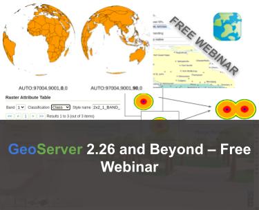
Raster Attribute Table Extension
A new extension is available that takes advantage of the GDAL Raster Attribute Table (RAT). This data structure provides a way to associate attribute information for individual pixel values within the raster. This provides a table that links each cell value in the raster to one or more attributes on the fly.


Thanks to Andrea Aime (GeoSolutions) for the development and NOAA for sponsoring this new capability. Please see the user guide Raster Attribute Table support for more information.
- GEOS-11376 Graduate Raster Attribute Table to extension
Geostationary satellite AUTO code
AUTO:97004 has been introduced as a new vendor extension to WMS AUTO codes. It implements the geostastionary satellite project and allows to change the central meridian as part of the GetMap request.

Thanks to Andrea Aime (GeoSolutions) for this work, and Eumetsat for sponsoring it.
Improved vector tiles generation
A few new vendor options have been added in GeoServer, that control how vector tiles are built, with the objective of producing smaller, faster, more useful vector tiles.
vt-attributes: comma separated list of attributes included in the vector tilevt-labels: when true, generates a sidecar-labellayer for polygons, with the label point of the polygon (vector tile clients generally cannot produce a good label placement otherewise)vt-label-attributes:: attributes included in the label point layervt-coalesce: if true, takes all features in the tile sharing the same attribute values, and coalesces their geometries into a single multi-geometry.
Here is an example style using the above vendor options, in GeoCSS:
@mode "Flat";

tiger:poly_landmarks {
  fill: gray;
  vt-attributes: 'CFCC,LANAME';
  vt-labels: true;
}

tiger:tiger_roads [@z > 11] {
  stroke: black;
  vt-attributes: 'NAME';
  vt-coalesce: true;
}

tiger:poi [@z > 12] {
  mark: symbol(square);
}
The GWC layer preview has also been improved to show the vector tile feature attributes on hover:

Thanks to Andrea Aime (GeoSolutions) for this work, performed in preparation for the FOSS4G-NA 2024 vector tiles workshop.
New image mosaic merge behaviors, MIN and MAX
These two new image mosaic merge modes activate when multiple images overlap with each other, choosing respectively the minimum and maximum value amongst the super-imposed pixels.

Thanks to Andrea Aime for the work, and the US National Research Laboratory for sponsoring it.
Registration information
To learn more about the new features and interact with the core developers of GeoServer, I cordially invite you to a free webinar on Wednesday October 30th 2024 at 11 Eastern Time / 3pm GMT / 4 PM CEST by registering at the link below!
Looking forward to seeing you on the webinar!
If you are interested in learning more about how we can help you develop a WebGIS using MapStore or help you achieve your needs with MapStore, GeoServer, GeoNode and GeoNetwork through our Enterprise Support Services, Professional Training Services and Subscription Services please contact us!
The GeoSolutions team,
